
Water
The Fine Print A Seeing Across Time Special Edition Series
In 1922, the American West was still largely a place people moved through rather than to. Phoenix had nearly thirty thousand residents, a modest agricultural city in the Salt River Valley. Las Vegas existed as a railroad service town, platted in 1905, but had not yet become anything resembling a major city. Los Angeles was growing rapidly but still oriented toward its harbor and its surrounding agricultural valleys. The automobile was widespread but still shared roads with horses in many parts of the country. The Interstate Highway System was more than three decades away. Air conditioning existed as an industrial technology but had not yet entered the American home, and the idea that it would one day make the Sonoran Desert a reasonable place to raise a family would have struck most people as either visionary or absurd, depending on their disposition.
Settlement in 1922 still followed an older logic. People lived near water because they had to. Cities grew along rivers and coastlines and lakeshores because those were the places where human life was sustainable without heroic feats of engineering. The West had its share of ambition, but the ambition was still operating within natural constraints that nobody had yet figured out how to ignore at scale.
In November of that year, representatives of seven western states gathered at Bishop's Lodge in Santa Fe, New Mexico, and divided a river.
In the Colorado River Basin in 1922, the Law of the River began! The Colorado River Compact of 1922 was approved on Nov. 24, 1922 and was the first agreement to legally connect the Colorado River Basin states. Arizona ratified the Compact in 1944. (Source: https://knowyourwaternews.com/1922colorado-river-compact-signed/)
The Colorado River Compact of 1922 allocated 15 million acre-feet of water annually between the Upper Basin states of Colorado, Wyoming, Utah, and New Mexico, and the Lower Basin states of Arizona, California, and Nevada, with an additional 1.5 million acre-feet later committed to Mexico by treaty. It was a remarkable act of legal architecture for its moment, an attempt to manage a shared resource across jurisdictions before the conflicts over that resource became irresolvable. The men who negotiated it were not reckless. They were working with the best hydrological data available to them, drawn from stream gauge records covering roughly two decades of measurement.
What they did not know, and could not have known, was that those two decades happened to fall within an unusually wet period relative to the longer historical record. Tree-ring reconstructions of river flow extending back centuries show that the early twentieth century was above the long-term mean in ways that the short instrumental record could not reveal. The river they divided was not the river that would show up for the next hundred years. They had written terms against an anomaly and called it a baseline.
That is the original fine print of the American West. The Colorado is the most visible expression of it, but not the only one. From the Rio Grande along the Texas border to the aquifers beneath El Paso and San Antonio, the entire arid West was built on water accounting that assumed more than the land could reliably deliver. The Colorado is where the reckoning is arriving first and most visibly. It will not be the last.
A Century of Managed Illusion
For most of the twentieth century, the gap between what the Compact promised and what the river could reliably deliver was managed rather than resolved. The construction of Hoover Dam in the 1930s created Lake Mead, and Glen Canyon Dam followed in the 1960s, creating Lake Powell upstream. Together the two reservoirs hold enough water to supply the river system for roughly two to three years at modern flow estimates, which meant that a string of dry years could be absorbed without immediate crisis, and a wet year could be banked against the next drought.
The infrastructure made the illusion sustainable. And the illusion made everything that followed possible.
Phoenix grew from a modest agricultural city into a metropolitan area of five million people. Las Vegas became the fastest growing city in the country for much of the latter half of the twentieth century. Tucson, Albuquerque, Salt Lake City, and the sprawling suburbs of Southern California all drew from the same system, all expanded on the assumption that the water would continue to arrive, and all built political and economic structures premised on growth that the hydrology, left unmanaged, could never have supported.
This was not unique to water. The same period that saw the Colorado River infrastructure take shape also produced the Interstate Highway System, which made the desert accessible, and the mass adoption of residential air conditioning after World War II, which made it livable. These were genuine engineering achievements, and they were transformative. But they shared a common quality with the Compact itself: they were solutions to constraints that nature had imposed, and they worked well enough, for long enough, that the constraints began to feel optional. The West that emerged from the postwar decades was a West that had learned to ignore its own fine print.
The fine print was patient.
What the River Knows
The twenty-first century has been a process of the river reasserting its actual terms.
A megadrought that began around 2000 and has not meaningfully relented has reduced the Colorado's average annual flow by roughly twenty percent compared to the twentieth century average. That average was itself drawn from a period that overstated the river's long-term capacity. The river carrying less water than a baseline that was already inflated is a compounding problem, and the reservoirs designed to absorb variability have spent the better part of two decades absorbing something closer to a structural deficit.
As of mid-April 2026, the numbers are stark. The Rocky Mountain snowpack that feeds the entire system is sitting at roughly a quarter of its thirty-year normal, the worst on record. The South Platte Basin, which supplies Denver and the surrounding region, is at four percent of normal. Lake Powell holds twenty-nine percent of its capacity. Lake Mead holds thirty-two percent. Federal forecasters project that spring runoff into Powell will come in at roughly a quarter of normal. The Bureau of Reclamation has warned that Powell could breach its minimum power pool elevation, the level below which Glen Canyon Dam's turbines cannot generate electricity, as early as this fall if conditions do not improve.
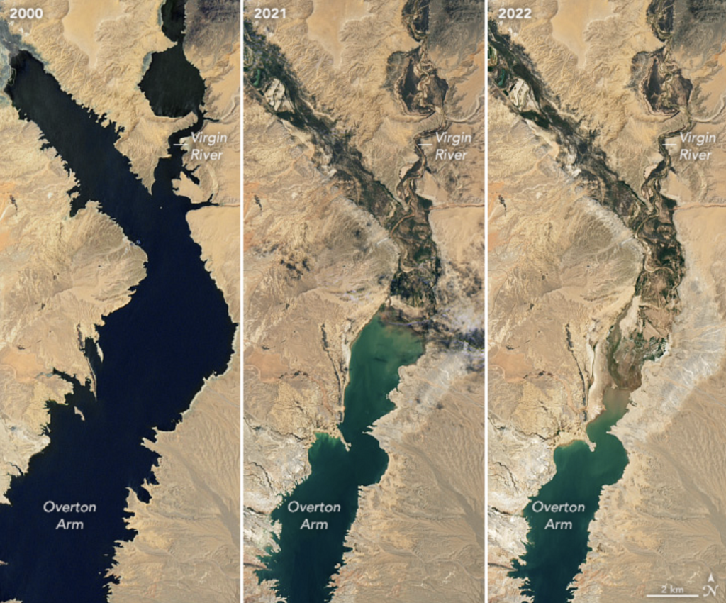
A comparison of water levels on Lake Mead from 2000 to 2022. NASA image. (Source: https://source.colostate.edu/colorado-river-compact/)
The seven states that share the river's water have spent years in negotiation over how to apportion the cuts that the hydrology now demands. Those negotiations have failed to produce an agreement. The Bureau of Reclamation has signaled it may impose its own framework if the states cannot reach consensus, with decisions expected by late summer or early fall. Water managers in Arizona, speaking to their communities with a directness that has not always characterized this conversation, have said plainly that the cities and towns relying on Colorado River water will receive less in the coming allocation cycle, and that the era of relying on the river as it has historically been relied upon is over.
That is not a negotiating position. It is a hydrological fact that has been deferred for a century and is now simply arriving.
The Food on Your Table
The consequences extend well beyond the cities, and in ways that will be felt by Americans who have never lived anywhere near the Colorado River basin.
The Imperial Valley in Southern California sits at the southern end of the Colorado River system and holds some of the most senior water rights on the river, dating to the early twentieth century. It is also one of the most productive agricultural regions in the country. The farms of Imperial County, along with neighboring growing regions in Coachella and Yuma, produce roughly two thirds of the vegetables Americans eat in the winter months, a contribution to the national food supply that is wildly disproportionate to the region's size and that depends entirely on Colorado River water delivered through a network of canals across desert terrain.
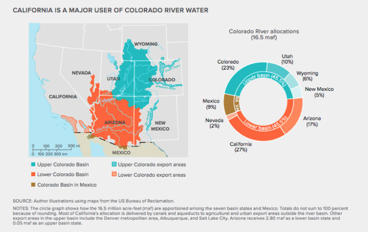
This chart outlines the water (in percentage and MAF) allocated to each state and nation within the basin. Allocations to Native Nations are not included. (Source: https://cwseducation.ucdavis.edu/class/116/history-colorado-river-compact-lessons-water-allocation-process-western-north-america)
The cities and the farms are drawing from the same overcommitted system. There is no separate agricultural allocation that sits outside the water arithmetic Phoenix and Las Vegas are now being forced to confront. Every acre-foot directed toward a winter lettuce field in the Imperial Valley is an acre-foot that does not flow to a residential tap in Tucson, and the cuts required to stabilize the system will force a reckoning between those competing claims that legal seniority alone cannot resolve.
Imperial County is also one of the poorest counties in California, with an unemployment rate that has fluctuated between fifteen and twenty-three percent in recent years and an economy in which agriculture accounts for one in every six jobs. The cuts required to stabilize the river system will land disproportionately on agricultural users, because agriculture accounts for the vast majority of Colorado River consumption and because municipal and industrial users have both greater political leverage and greater economic value per acre-foot.
What that means, at the far end of the supply chain, is that the winter vegetables on American tables in the coming decade will be produced under conditions of increasing scarcity, at increasing cost, from a region whose economic fragility makes adaptation difficult and whose water rights, however senior, cannot conjure water that is not there.
The Colorado River built the modern American West. Not metaphorically — literally. It built the cities, the suburbs, the agricultural valleys, and the political economy that grew up around all of them. Every glass of water in Phoenix, every head of lettuce in a January grocery store, every kilowatt of electricity generated at the base of Hoover Dam traces back to a river that was always carrying less water than the documents said it would.
The men who wrote the Compact in 1922 were not villains. They were operating at the edge of what their instruments could measure, in a world where the desert was still largely empty and the idea of engineering around its natural constraints was just beginning to seem possible. They made a reasonable agreement about an unreliable resource and left the adjustment to future generations. Future generations, for most of a century, chose not to adjust.
They chose instead to build. And what they built was extraordinary, and fragile, and premised on terms that the river was never actually offering.
The water is one thread. The assumptions that ran alongside it — about risk, about land, about what it costs to live in places that were never designed by nature to hold this many people — are the rest of the story. That story is still being written, and the next chapters are arriving faster than most people expected.